Mapping the World by Heart Teacher Spotlight: Jessie Jung
This week’s FableVision Learning Teacher Spotlight was written by Jessie Jung, a teacher at Andrews Academy. For the past eight-years she has intermediate social studies.
“Teaching in an independent school affords a lot of curricular freedom, and our social studies program is ever evolving,” she explains. “We have chronologically organized our topics to span from the Age of Exploration in second grade all the way to the Civil Rights Movement in fifth grade. We have also worked to align our geographical studies with these concepts.”
In this post, Jessie shares a bit about how she uses David Smith's Mapping the World by Heart in the classroom and offers a few tips on how to get started.

How were you introduced to Mapping the World by Heart?
My friend and colleague, Nikki McGuire, brought the Mapping the World by Heart curriculum to our school a few years ago. She introduced the concept to her fourth grade social studies classes by having them map the United States by heart. The maps turned out beautifully, and we decided that just like our linear social studies curriculum, we would ultimately like to spread and spiral the mapping through several grade levels; mapping Missouri in third, the U.S. in fourth, Europe in fifth, and Latin America and the Caribbean Islands in sixth.
What makes the program different than other geography curriculum?
Mapping the World by Heart is a unique curriculum. It is very flexible and you can tailor it to your teaching style. You can make it belong to you and your students.
Every now again you get the “but do students really need to know this?” question. First of all, yes. I want my students to be globally focused. I realize we are only mapping Europe, but looking at life outside of our country makes us more aware that there are others inhabiting this planet. Secondly, being able to map requires using a totally different way of thinking than students are used to. It gives their visual-spatial intelligence and problem solving skills a workout. Think process not product! That being said…the finished product is something that students are extremely proud of.
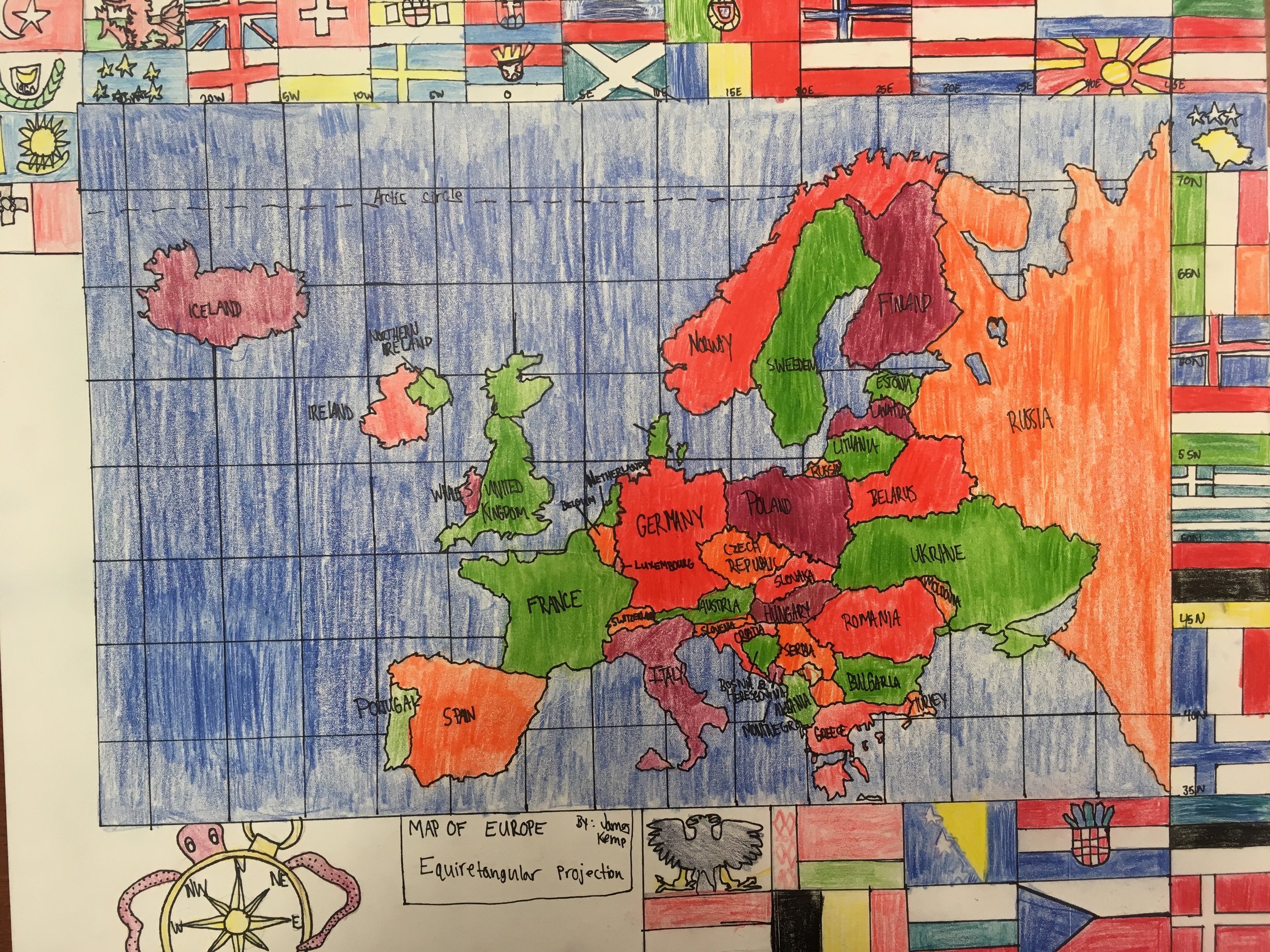
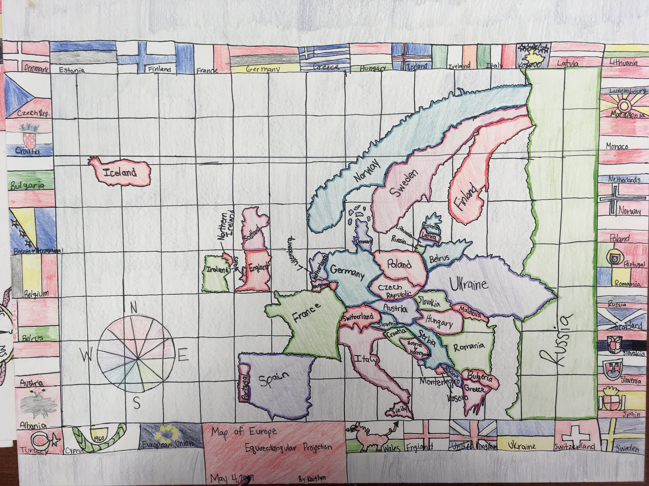
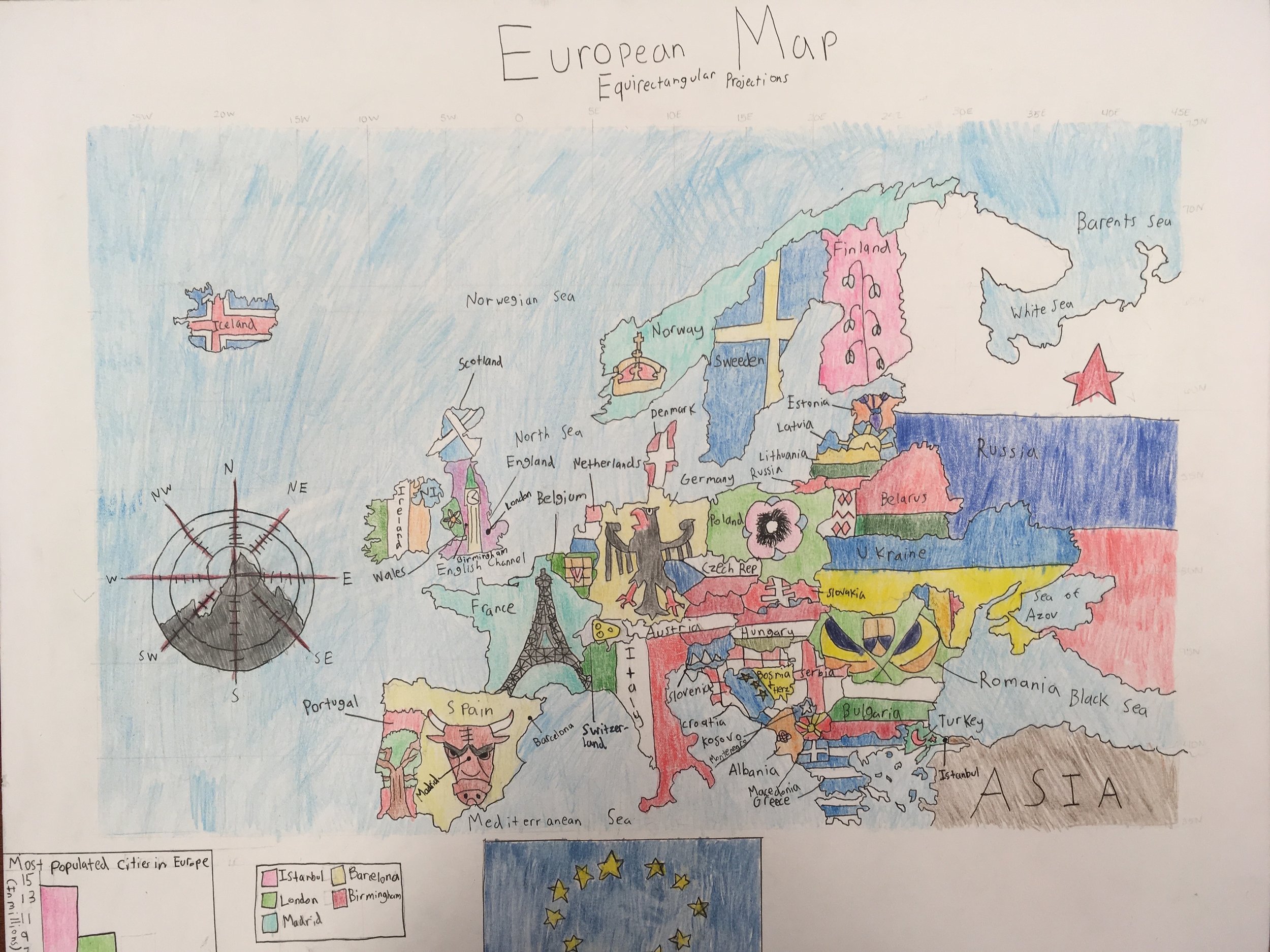
Many of my students channeled their artistic skills into their maps. A few students created a border of European flags around their map. Instead of coloring the countries a single color, another student drew a national symbol on each country. Some students included sea monsters, ships, and castles on their maps. Mapping was definitely one of the most memorable things that we did this year. In fact, several of the graduating sixth graders named mapping as one of their favorite things that they did in their school careers thus far.


How are you using the program in your classroom?
We decided that fifth grade would map Europe, which would dovetail into our units on World War I and World War II. The 2016 - 2017 school year was my first year mapping with my students. I had a couple of secret weapons in my arsenal; I had Nikki as a mentor, and my students had already mapped the U.S. the year before, so they had some serious prior knowledge. We began by memorizing the locations of the countries of Europe. We spent a couple of weeks splitting up the countries and creating memory devices to help us remember the shapes of the countries (Finland looks like a Fancy dress).
Then a few things became clear:
This was helpful for a handful of countries, but a lot of the European countries were pretty similarly blobby
The cost (time) was outweighing the benefit
I was stalling - it was time to jump into the deep end!
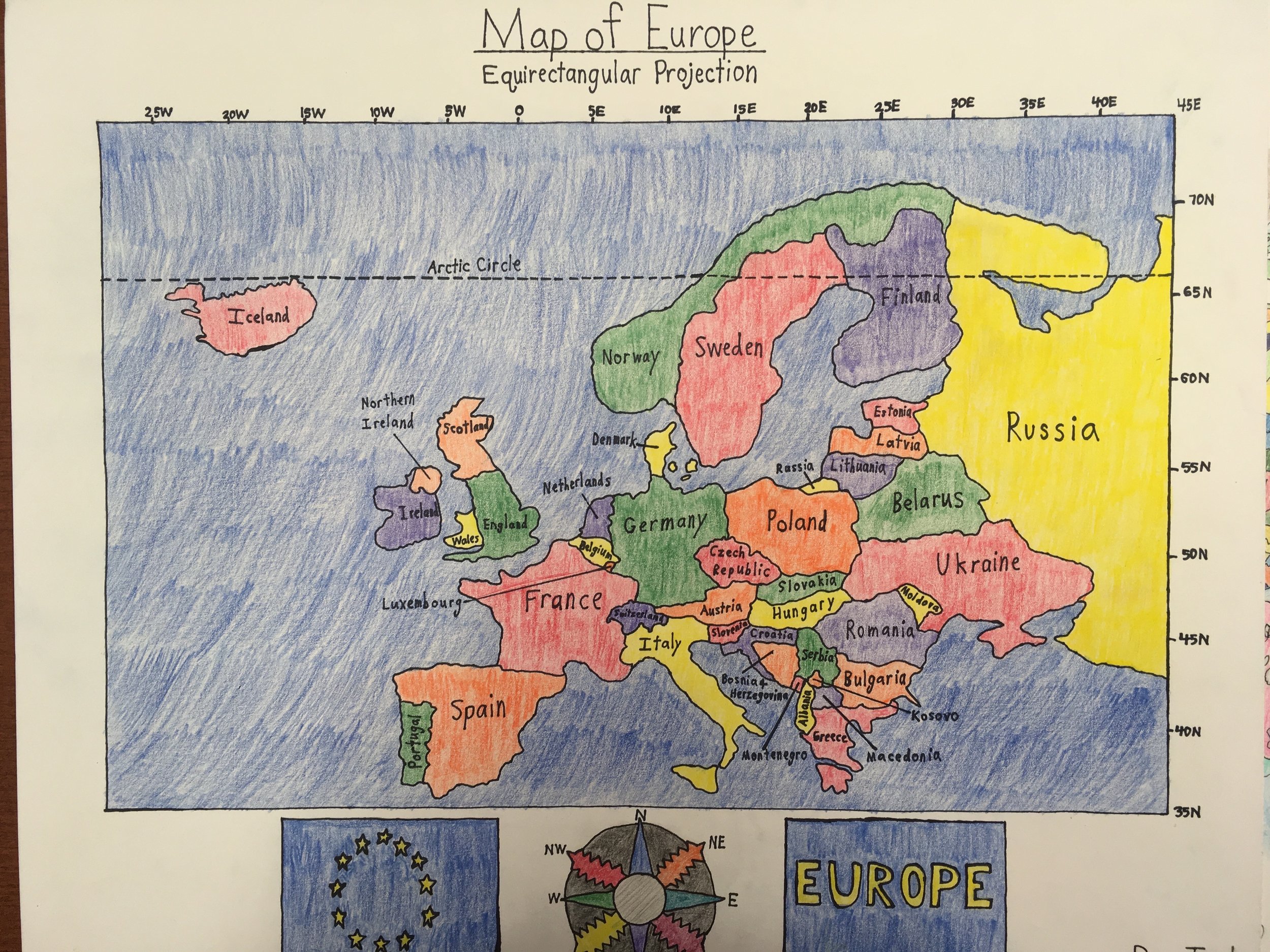
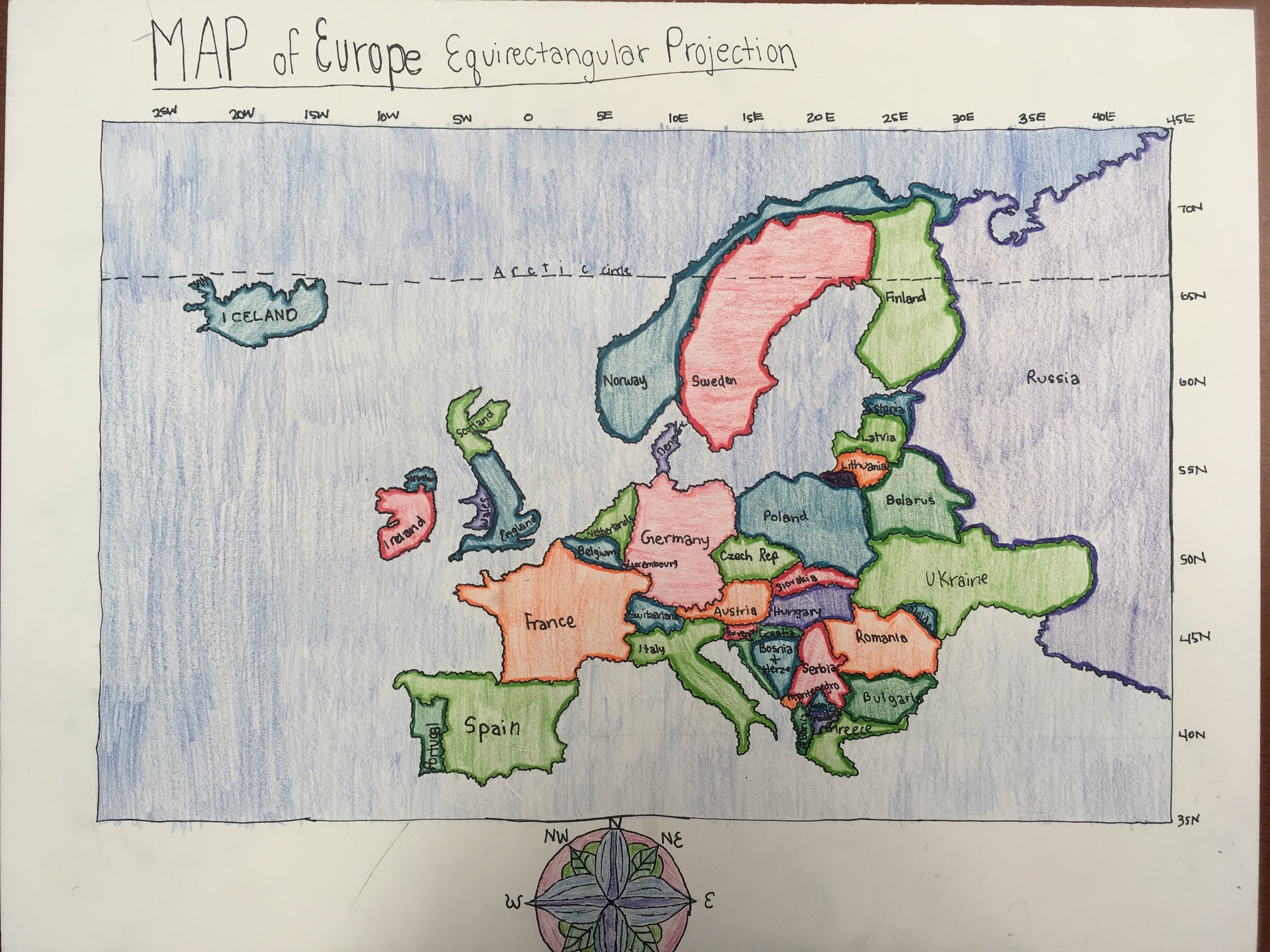
So we started with Iceland and the Arctic Circle, and we moved east. In the beginning, I really tried to cling to steering wheel, and have each student map each country together, but I had some students flying on ahead and other students still trying to perfect Iceland’s northern coast. So I let go. I circulated the classroom, looking for the key longitudinal and latitudinal markers to help keep the students on track. We broke the forty countries that we would be mapping into groups of ten, and then we mapped that section 3 times. Ten countries three times, followed by twenty countries three times, then thirty countries three times, and finally forty countries three times. We penciled and inked our final maps, created a color path, and transferred the color path to the final map.
What tips can you offer to a teacher starting out?
For teachers who are just starting off with Mapping the World, I would say, don’t be intimidated, it doesn’t need to be perfect. Your students will inevitably come out the other side of the program with more geographic awareness, refined problem solving skills, and a better sense of being a global citizen. For me, letting the program flow and evolve was key. Set manageable goals, and step them up each year. Get your students involved. Let them help you work out the logistics of the map.
What was one aha moment using Mapping the World by Heart?
Letting go was a big aha moment in this process. I am not necessarily a detail person, and I was stressing about using the curriculum as an exact science. Then I realized, I need to mold the curriculum to work with my strengths and my students’ strengths. I thought about what I realistically wanted for my students in this first year pilot program. I wanted them to know the European countries and their general shapes and locations. I also wanted them to surprise themselves and feel confident and proud of their maps. Realizing that this curriculum would be a process that would become more polished every year was key.
What is next?
Some of my fellow teachers test the students over their final map of Europe. This year, our maps were more of a project, and less of a memorized assessment. Next year, I plan to have students create three maps of Europe, a modern map, a map of Europe on the eve of WWI, and a map of Europe under Nazi occupation during WWII. The original map will be on tag board, and the WWI and WWII maps will be on tracing paper pages, laying over the tag board, illustrating the evolution of the continent.
Using FableVision’s books, media, and/or software in creative or interesting ways? Click here to nominate someone for the FableVision Creative Educator Spotlight and complete your submission electronically.