Mapping the World by Heart Teacher Spotlight: Nikki McGuire
This week’s FableVision Learning Teacher Spotlight was written by Nikki McGuire, a teacher at Andrews Academy. In her 12-year career, she has taught at various schools in Missouri before settling at her current position. In this post, she shares just what makes David Smith's Mapping the World by Heart an invaluable tool in her classroom.

I was introduced to Mapping the World By Heart while teaching at the Forsyth School. My friend, Jim Dowd, fellow fourth grade teacher, coached me on how to bring mapping to life in my fourth grade social studies class. Forsyth had a memory mapping piece at the fourth, fifth, and sixth grade levels. Fourth grade learned to memory map the US, fifth grade mapped Europe/Africa I believe and sixth grade mapped the world by heart! I was amazed at how these students could learn to do this! It is incredible!

On the surface many people are quick to criticize Mapping the World by Heart as just memorization, but it is so much more. I have had many questions about what the use is, or maybe if it is just a waste of time. However, after mapping the US with 7 different fourth grade classes in two different settings, I can say it is one of the most rewarding teaching experiences! It is a wonderful process, but also an amazing product. Most of the kids frame them and hang them in their homes. They are a remarkable work of art! They will forever have those geographical ‘hooks’ to link future concepts of geography and history. It is well worth the time and effort it takes to teach and complete!

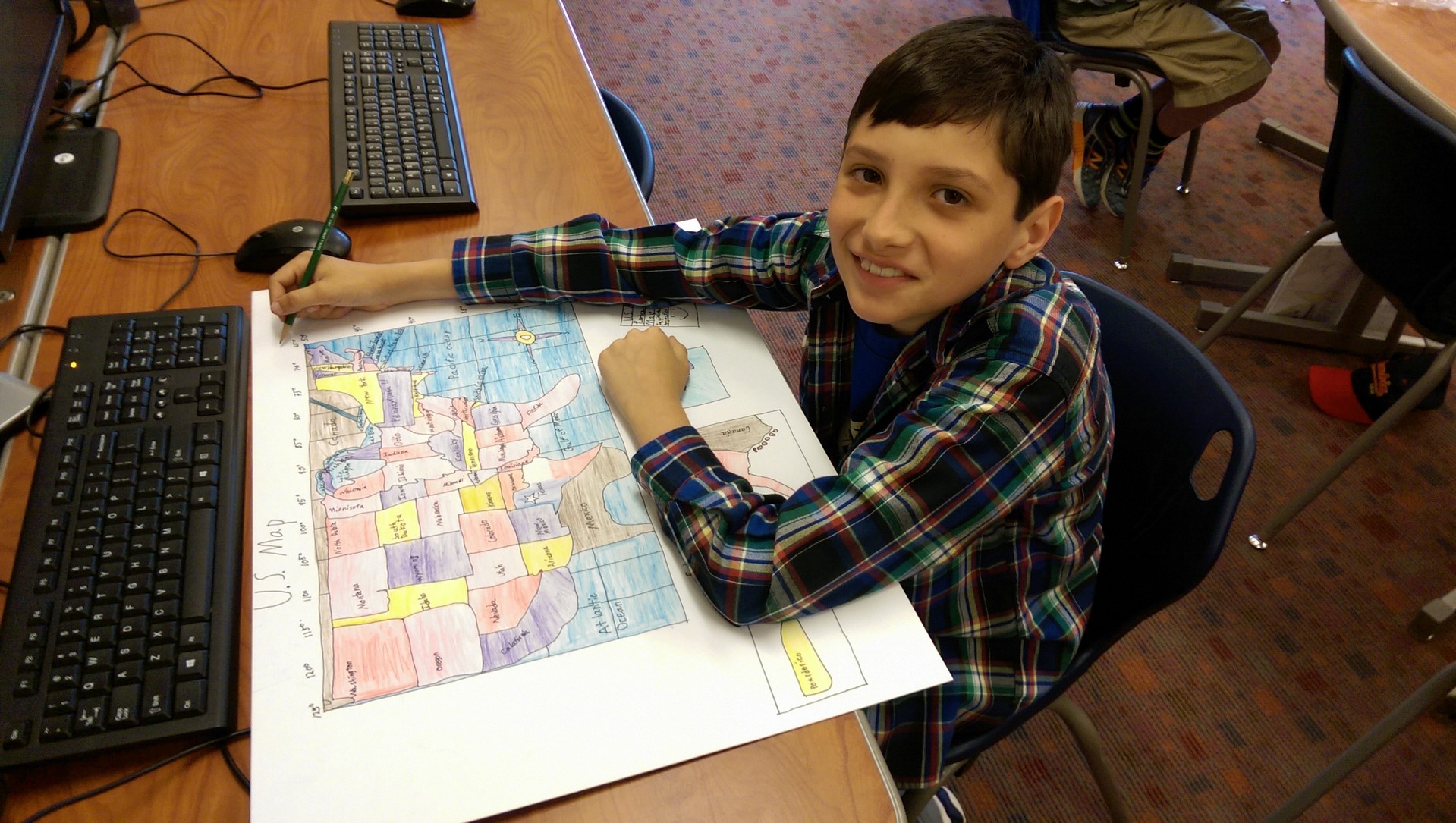
In my opinion, there are two types of memory mapping. One type is what I call "free drawing." That is where the shapes of states and countries are drawn in their proper location in relation to all the states or countries that border them, but it is not necessarily on the longitude and latitude grid system. The other is more precise and teaches the students to draw using the lines as guides, and really works to draw the countries and states in the "right" place. Both are beneficial. We use the grid system in tandem with free draw. The final map is done solely from memory, and takes place over 3-4 sessions, about an hour each. The students set goals and map to their goal. They are free to practice in between sessions or for homework, then continue on to their next goal.

I always begin the school year with a memory map which is usually really inaccurate! We save these maps and compare them to our final maps at the end of the year and then write about how it felt to draw from memory in August, versus in May. We spend several weeks working on map skills, memorizing the spellings or all the states and countries, and we complete many black line maps and test on the locations before we ever begin mapping lessons.
We talk a lot about different projections and how projections change the look of the map. Because I had never taught mapping Latin America, I did not have a longitude and latitude projection grid drawn out to use, so I decided to let my students plan one of their own after studying different projections. I played around with it and had a decent idea of a grid that would work, but one of my students figured out a great one, and it is the one we are all using! A lot of thinking, trial and error, and reasoning go into finding the right intervals, spaces, shape of rectangles, number of lines, etc. I was really proud of all the efforts made by my students. It really helped them understand how different projections can make your countries look long and thin, or short and fat, or too tiny, or too huge!

My biggest tip to anyone teaching memory mapping is to let go a little. Teach it in manageable chunks, and practice, practice, practice! Keep it fun, and don't be overly critical. Have the students take on the role of teacher. I also recommend that as you progress through the states, or countries, always draw them in the same order in the same way. In this way, it becomes almost rote. As you add chunks, always have them draw ALL the states up to the new chunk. For example, if you draw Washington, Oregon, Idaho...always start that way. When you add Montana, Nevada, California, always draw WA, OR and ID first, then add the next three, and so on.

I have found that the some of the most unlikely students will surprise you while mapping. Students with disabilities, little creativity or poor art skills often excel. Everyone can be successful with memory mapping!