Mapping the World By Heart Classroom Spotlight: Robin Clements

If you were to map Robin Clements teaching career, it would start and end with 8th grade. Currently an 8th grade teacher at St. Bernard’s School in New York, Clements is a “long-time admirer and even acolyte” of Mapping the World by Heart creator, David Smith. At every school, he has used the geography curriculum, Mapping the World by Heart, in his classroom to teach a number of different lessons besides just the borders of countries.
Clements said he caught the “mapping” bug in the early 1980s when he was headmaster at the Hillbrook School in California.
“(I) got the 6th grade teacher on board (and) she took Dave’s program pretty much as packaged for 6th grade history and geography, stretching it out over a whole year, with many activities of her invention to go with each phase,” he explained. They drew Africa as they were reading African folktales from different countries; their study of Asia was part map drawing, part culinary, and so forth. The kids loved it. At the end of the year, they drew the whole world in one mighty day, colored and decorated their maps and took them home to proud parents. It became a staple of our curriculum, a hallmark of our school.”
Moving across the country to the St. Bernard School in New York, Clements he got the green-light to do a seriously modified form of the map for 8th grade history and adapted Mapping the World by Heart to fit the curriculum.
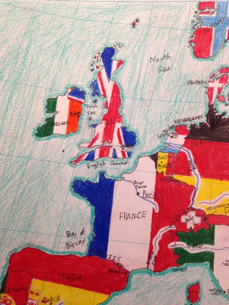
“As the existing curriculum was medieval Europe, I found a conical projection of Europe that by chance included the Mideast, Northern Africa, and the countries of the Caucasus. The map was made into a desk-sized blank by a New York architect (who said getting the latitude right was one of the hardest things she had ever done), and I took the result to a printer, who did a thousand copies on cheap paper and fifty on heavy stock,” he shared. “We are still at it. Boys take about five weeks to learn the whole thing, starting with the water, then populating the blank spots with countries, capitals, mountains, and rivers. The guys get four class periods on successive days to draw and ink it. It took me about 10 years to figure out how to teach it and how to grade it, but I can now do it pretty easily.

You will see that it is not Dave’s pure idea at all, but it’s working well, most of the boys love the break from reading and essay writing, and there are often big surprises—the verbal genius who struggles with spatial relationships, the verbal problem who suddenly blossoms. It’s a different part of the brain. All in all, it’s been a success and I now have almost twenty years of victims to tell me how useful or un-useful it was. The consensus is quite useful in high school, and there are a couple of touching success stories.”
We recently connected with Robin Clements to share a bit about his work with Mapping the World by Heart in the classroom.
Can you share a bit about your career and you current position at St. Bernard's School?
I’ve been teaching just about forever—elementary school, college, high school—and was headmaster of a country day school in California for 21 years. I began with 8th grade as an apprentice at Hawken School in Cleveland in 1965 and it looks as if I’m going to end with 8th grade at St. Bernard’s School in New York. I’m a homeroom teacher with 20 boys and a couple of classes of medieval history, a couple of classes of Latin and a 7th grade geography class, plus all the homeroom stuff.
What is the role of geography in the classroom?

Heavens. It comes into every discussion if you give it time. I’ve got old-fashioned roller maps in a nest of four above the blackboard and I’m constantly changing them and reaching for one or another. In homeroom, we come to the Korematsu case—down comes the map so we can look at Hawaii, since the events started just after Pearl Harbor with a crash landing on Ni’ihau. Then on to the Bay Area, and finally Western Utah, where Korematsu spent most of the war. Pointing to spots on a map is so, well, old-fashioned, and yet I think it helps the boys remember the flow of the story.
We also have a good Internet connection, and there are endless uses. About how many people are there in Iowa? I have no idea, but Dr. Internet serves up the answer in a flash. One of the boys just wheels his chair around and looks things up. Google Earth is endlessly useful. Drawing the border between Jordan and Iraq raises the question of that little hiccup in the middle of a very straight line. Put it up on the board and let’s zoom in. Oh, look—it’s an airport, and the national boundary moves to keep it in Iraq. Geography ought to be as much part of elementary education as spelling or times tables.
What has been one aha teaching moment with Mapping the World by Heart?

You don’t mean things like “Hungary looks like a chicken,” do you? (And Ireland like a koala bear, and Switzerland astonishingly like a praying Muslim.) How about this: why does the western border of Armenia bend to the east? What is it avoiding? As you draw it, let’s talk about the history of Turkey and Armenia, a murderous hostility that finally deprived Armenia of its national symbol, Mt. Ararat. The whole story is something I knew only hazily before I began to teach the course, but it really pops out as you draw that line, and talk about the post-World War I war between Armenia and Turkey. Boys who draw this line are likely to tuck the story away, I believe.
Are you or someone you know using FableVision Learning’s creative tools for the classroom. We would love to feature them on our blog. If you'd like to nominate someone for the FableVision Creative Educator Spotlight, click here and complete your submission electronically or send us an email at info@fablevisionlearning.com